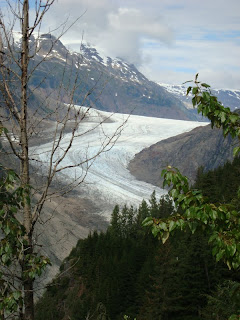
Our last stop in Alaska was Hyder which is in southeastern AK and is just across the border from Stewart, BC. We actually stayed in Stewart and drove across the border to Hyder. Stewart is the northern most ice free port in Canada and is on the Portland canal which leads directly into the Pacific ocean. Hyder's main claim to fame is bears and glaciers and renewed interest in gold mining. Stewart is a nice little town with paved roads; as soon as you cross the border into AK the paved road ends and you drive on a dirt road with many ruts and potholes. It is almost as if you are going back to the gold rush days. Outside of the town is Fish Creek which is in the Tongass National Forest. There is a raised boardwalk along the creek where people can safely watch black and grizzly bear come down to feed on the salmon that have come "home" to spawn and die. The bear pictures are from around the veiwing area. They must have eaten enough fish and were more intrested in berries. The Salmon glacier which is further out of town is spectacular. It is one of the larger glaciers we have seen and you view it by looking down on it. It is also rather unique in that it divides and has two terminations. The left fork called the foot and continues to melt away. The right fork ends in a dry valley but the face of the glacier calves off. It was well worth the drive. There are also glaciers along the road to Stewart one is Bear glacier not to far from town.
 |
| ON THE ROAD TO HYDER |
THE PICTURES BELOW ARE OF BEAR GLACIER NOTICE THE CHANGES BETWEEN THE 2004 AND 2011 PICTURES THAT I TOOK
 |
| BEAR GLACIER 2004 |
 |
| BEAR GLACIER 2011 DINING IN STEWART |
 |
| |
 |
| FINE DINING IN HYDER |
 |
| BETTY WAS ABLE TO GET REAL CLOSE TO A BEAR |
 |
| NOTE THE SPAWNING SALMON THE REASON FOR BEAR ACTIVITY IN THE AREA |

 |
| JUST ANOTHER WATERFALL |

 |
| THE TOE OR LEFT FORK |
SALMON GLACIER FROM THE SUMMIT
 |
| NOTE THE WAY THE GLACIER SPLITS TO THE LEFT AND RIGHT |
THESE PICTURES ARE OF THE RIGHT FORK WHICH IS CALVING
 |
| THE CALVING LINE FROM ABOVE |
 |
| THE CALVE LINE FROM FURTHER AWAY |
 |
| LOOKING FROM THE RIGHT SIDE ACCROSS TO THE LEFT SIDE, JUST MASSIVE |


JUST MORE GLACIERS NOTE THE ONE ON THE LEFT GOING AROUNT AN OUT CROPPING OF ROCK


 |
| THIS AREA USED TO BE A GOLD AND COPPER MINING AREA IN THE 1920s. NOW THERE IS LOTS OF RENEWED ACTIVITY |
 |
| UNKNOWN STRUCTURE |


No comments:
Post a Comment